A Whiteparish local history page from younsmere-frustfield.org.uk
See also Broxmore House and Park.
Broxmore Farm lies in the extreme southeastern corner of Whiteparish within the detached section of Alderstone Manor, with its full extent shown overlaid on a Google Earth satellite view below. It is in two parts divided by the access road to Melchet Court from the A27 at Melchet Pond (this is the road that runs through the main archway entrance to Melchet Court).
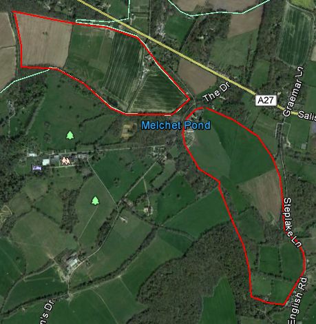
The two parts of Broxmore Farm in 1842 shown on a Google Earth background
Copyright 2018 Google
The map below shows the two parts of Broxmore Farm in context within the southeastern section of Alderstone Manor from the 1842 Tithe Map, stretching as far as Plaitford.
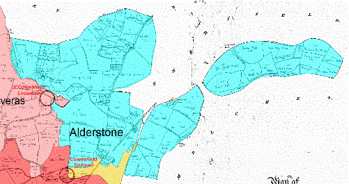
The eastern part of Alderstone Manor taken from the 1842 Tithe Map (for full map see here).
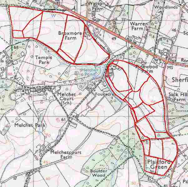
The map below shows the extent of Broxmore Farm traced off the 1840 tithe map (red) and placed on a modern 1:25000 scale map. Many of the field boundaries and two small sections of woodland from 1840 are still present. This detached part of Frustfield and the parish of Whiteparish was transferred into the parish of Plaitford in the boundary changes of 25th March 1885 and has since been merged with Melchet Park to form Melchet Park and Plaitford parish. See the boundary changes section of the Whiteparish maps page for further details.
Taylor observed in 1967 that "The land southeast and southwest of Broxmore House, including the detached part of the parish, is divided into near equal sized fields, bounded by almost straight hedges. The name Purlieu Field denoting land on the edge of a forest that has been disaforested, is significant." Unlike the straight edged fields he describes, Purlieu Field (parcel 1359) has the curved appearance of an initial field carved out of forest by clearance, as does Round Field (parcel 1352) nearby.
Broxmore Farm was built soon after Melchet Forest was disafforested and enclosed in 1610, at about the same time as Ash Hill House. Taylor observed in 1987 that that the architecture of the present farmhouse agrees with this date.
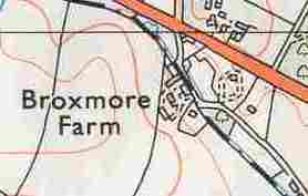
A tracing of the 1842 Tithe Map representation of Broxmore Farm overlaid on an old Ordnance Survey map
Two buildings at Broxmore Farm are listed: a granary dated to around 1700 and an early 19th century barn that reused some 17th century bricks.
Between 1970 and 1991 the southeastern detached part of the farm became Greenvale Farm, with entirely new buildings constructed on a green site to the south of Pinewood Farm at the west end of the area opposite Melchet Pond and alongside the access road to Melchet Court.
.gif)
Broxmore Farmhouse in 2004 Historic England Listed Buildings
Copyright IoE Mr John Rendle Source Historic England Archive
.gif)
Broxmore Barn (from estate agent's leaflet referenced below)
Estate Agent's leaflet for Broxmore Barn from here, viewed and link valid on 10.3.2021.